

We wanted to head north. We wanted to visit Norway. We wanted to see the North Cape. And we didn't want to take the same route there and back. So we planned a journey through Poland, Lithuania, Latvia and Estonia, across the Baltic Sea and all the way through Finland. Six weeks in our van and almost ten thousand kilometres lay ahead of us, filled with beautiful scenery, historic cities and unforgettable experiences. Here we go!
Travel Plan
Day 1
Wrocław
Noch bevor wir losfuhren, verpassten wir unserem Sprinter ein paar Rennstreifen, damit die Fahrt schneller vergeht. Gegen Abend erreichten wir Breslau. Für die erste Nacht hatten wir einen Stellplatz im ehemaligen Olympiastadion ausgesucht. Heute ist das Gelände eine Mischung aus genutzten und verfallenden Sportanlagen. So findet man dort ein modernes Stadion des örtlichen American-Football-Clubs und gleich daneben ein völlig zugewuchertes olympisches Schwimmbecken. Vom Stadion fährt eine Straßenbahn direkt ins Zentrum, sodass wir schnell in der Stadt waren. Wir schlenderten durch die Altstadt und ließen den Abend in einem echten polnischen Bistro ausklingen – einem koreanischen.
Insgesamt 297 km


Day 2
Wrocław


Day 3
Treblinka
Kętrzyn (Wolf’s Lair)
In the morning we headed farther north. About a hundred kilometres beyond Warsaw we stopped at the site of the Treblinka extermination camp. Nearly a million innocent people were murdered here by the Nazis. Today, stones arranged around a monument commemorate the victims in this peaceful place.
By evening we finally reached the Wolf's Lair. During Operation Barbarossa, the invasion of the Soviet Union, this was Hitler's headquarters. It was also the scene of the failed assassination attempt known as Operation Valkyrie.
Around 200 structures were built across 250 hectares: air-raid shelters, smaller concrete and brick buildings, and wooden barracks protected by surrounding lakes and marshes. The bunkers grew larger over time, eventually boasting concrete walls several metres thick. In 1944, with the Red Army approaching, Hitler ordered the bunkers destroyed and fled to Berlin. Neither the Germans nor anyone else managed to demolish them completely, so these enormous, partly ruined monsters still hide in the forest. We explored them that very evening armed with nothing but torches. Truly unforgettable.
We slept right on the site, just metres from the first bunkers.
Total: 296 km


Day 4
Śluza Leśniewo Górne
Mamerki
Wisztyniec Tripoint
We didn't sleep much. The place still has a strange atmosphere. And at six in the morning a team of lumberjacks arrived and began cutting down trees nearby. So we had breakfast, explored the grounds once more, visited the newly opened indoor exhibitions and moved on. Our next stop was an artificial canal intended during the Second World War to connect the Baltic Sea with the Masurian lakes. It was never completed, but several locks remain. The best-known, decorated with a Nazi eagle relief, now serves as an adventure ropes course.
We also stopped at the Wisztyniec tripoint, where Poland, Lithuania and Russia's Kaliningrad region meet. The fence between Poland and Lithuania was about five metres long, and then nothing – just for appearances. The Russian side, meanwhile, had two barbed-wire fences and cameras monitoring every movement. Pure Mordor, complete with Saruman's eye.
Total: 300 km


Day 5
Trakai Castle
Vilnius
Hill of Crosses
Riga
And that's it – we're in Lithuania! We camped beside Trakai Castle, an iconic 13th-century island castle near the capital. In the outer courtyard we bought some famous local kibinai for breakfast: pastries stuffed with meat, mushrooms or vegetables. They tasted good, but were greasier than our engine's underside.
After breakfast we headed for one of Lithuania's most important pilgrimage sites, the Hill of Crosses. It's more of a low, man-made mound than a mountain, and believers have been bringing crosses here since the 19th century. Their number grew under Soviet rule, despite repeated attempts by the authorities to bulldoze the site, most recently in 1985. People kept returning with new crosses. There are now estimated to be more than 100,000. Pope John Paul II brought one here in 1993.
Total: 378 km


Day 6
Turaida Castle
Gauja National Park
We reached Riga, Latvia's capital, that evening, parked by the River Daugava harbour and headed into the centre. The atmosphere of this relatively small capital charmed us: beautiful historic houses, the oldest dating from 1490, friendly people, live music drifting from restaurant terraces and everyone having a wonderful time.
The next morning we continued north. We only saw Turaida Castle, on the edge of Gauja National Park, from the outside. After an hour's steep uphill walk, we finally reached the gate and learned it was closed that day. So back down to the van in pouring rain. At least the return journey was downhill.
And that's where our adventures with Latvian roads began. Many major roads were being rebuilt, but that didn't mean they were closed. We waded through mud between excavators, with no traffic lights, guessing which stretches of asphalt were ready to drive on. When we asked locals how to tell where to go, their only advice was: 'Hard to say. You'll have to try it...'
We stayed at a campsite by Lake Raiskuma. The owner was a passionate admirer of Norwegian campsites, so the place was crammed with garden gnomes and wooden cabins with grass roofs.
Total: 112 km


Day 7
Pärnu
We drove along the Gulf of Riga to Pärnu, a resort town with endless sandy beaches, already half empty as the season drew to a close. On our way back to the van, we heard live music from a restaurant terrace. We couldn't understand a word the band sang, but enjoyed it so much we stayed until the end. We later discovered they were one of Estonia's most famous bands.
The next morning we headed to the spa town of Haapsalu, on its namesake bay, famous for therapeutic mud and a peaceful atmosphere. What caught our attention most was its abandoned railway station, where Tsar Nicholas II arrived as its first passenger in 1908. Today it's a museum and outdoor exhibition. You can climb onto old carriages and locomotives and peer through their grimy windows.
Total: 267 km


Day 8
Haapsalu
Rummu
Tallinn
From Haapsalu we continued north to a flooded limestone and marble quarry near Rummu. A labour camp and prison were established here in the 1940s. Forced labour, extreme danger and inhumane conditions caused immense physical and mental suffering to prisoners ruthlessly exploited by the Soviet Union. After its collapse, the camp closed, groundwater pumping stopped and the quarry flooded. Today it's a popular swimming spot, with views over the site from a huge ash hill.
In Tallinn we again parked by the harbour and walked into the centre. The city is an incredible mixture of history and modern technology. Autonomous delivery robots with flashing lights zip across the square beside the oldest town hall in the Baltic and Scandinavian region, built in 1404. Everything is digital and ultra-modern.
Back at the campsite we met our German neighbour beside his enormous motorhome bus. He was driving his little Smart car into the bus's garage – his runabout for exploring cities. Soon he emerged looking miserable: his wife had blown the fuses by running the washing machine and dishwasher at the same time...
Total: 107 km


Day 9
Helsinki
In the morning we boarded the ferry to Helsinki. We'd booked tickets in advance, so everything went smoothly without a frantic purchase at the port. We simply waited for our registration number to appear on the display and drove through the assigned gate. Fifteen minutes after departure, an announcement told us we'd entered international waters. Instantly the slot machines started ringing, the duty-free shops opened and the alcohol shelves became particularly busy. Our resident gin lover didn't hesitate either. Suitably stocked up, we enjoyed the crossing and watched the unsteady Finns returning from a boozy weekend in Estonia.
In Helsinki we parked near the harbour and walked into town. Passing the old market hall beside our parking spot, we reached the famous Kauppatori market, where you can try traditional dishes, buy crafts or pick up a souvenir.
Evening was approaching and we had to move on. Farther north, through endless Finnish forests and past tens of thousands of lakes.
Total: 230 km


Day 10
Mikkeli
Kajaani
We spent our first Finnish night beside Lake Visulahti near Mikkeli. The place must be busy with holidaymakers and swimmers in summer, but now it was deserted. Just us and a few people in the lakeside sauna.
It had been raining heavily since the evening, so we packed up in the morning and continued. We discovered a beautiful spot near Kajaani by chance: a peninsula jutting into Lake Mieslahti where locals had created an area for barbecues, saunas and swimming. We had it to ourselves, apart from a few people visiting the old wooden sauna. We also discovered a Western innovation we could previously only dream of – a polystyrene toilet seat on the outdoor latrine. A miracle...
Total: 330 km


Day 11
Oulanka National Park
On the way to Oulanka National Park, we came across one of Finland's stranger sights: thousands of bizarre scarecrows standing in a roadside meadow. We stopped to investigate. The installation is called Hiljainen kansa, 'The Silent People', and symbolises Finns and their relationship with nature. To feel closer to nature ourselves, we bought some outrageously expensive juice made from rowan leaves at the nearby shop and continued.
As if by magic, just after entering Oulanka, we finally saw our first reindeer.
Oulanka is a peculiar place. Dense forests of slender trees like toothpicks stuck into the ground. Lingonberries as far as the eye can see, both red ones and blue ones that taste of nothing. Huge edible mushrooms everywhere, which nobody bothers to pick. At our nature campsite we talked to the owner about winter temperatures down to minus 30, the Northern Lights, and how he'd seen just one bear in fifteen years despite there being plenty around. He was more frightened of the Russians, just 15 kilometres away, than the bears.
Reindeer wandered through the campsite too. Including two albinos.
Total: 317 km


Day 12
Sodankylä
A few kilometres north of Oulanka we crossed the Arctic Circle. We nearly missed the modest roadside monument. What a contrast to the same spot in Norway, with its entire Arctic Circle visitor centre.
In the afternoon we reached Sodankylä and spent the rest of the day soaking up the sunshine, almost as if we knew it would be the last we'd see for weeks. Our evening walk ended at a bistro serving Arctic burgers made from reindeer. It seemed odd to eat these adorable animals. A local speciality, perhaps – but it tasted fantastic.
Total: 266 km


Day 13
Karigasniemi
Stabbursdalen
This was it. All of Finland behind us, we arrived at a sleepy border crossing into Norway. Two Norwegian customs officers, whom we'd apparently interrupted in the middle of doing nothing, let us in after a short chat – even with more Czech beer than the permitted allowance. Luckily they accepted our explanation that we'd be spending a whole month in Norway and that we Czechs need something to drink. They smiled and wished us a good journey.
Near Stabbursnes we stopped at a large recreation area packed with children on a school trip. We joined a row of vans and caravans to enjoy our first evening in Norway – at a children's camp. Once darkness fell, the Norwegian campers switched on decorative lights, gathered around a huge portable speaker and launched into a party worthy of a fairground. Only we and a Polish motorcyclist stared in disbelief, waiting for them to go to bed.
Around midnight we looked out of the window. There it was – our first Northern Lights!
Total: 408 km


Day 14
Nordkapp
The winding road along Porsangerfjord went quickly at first. Every bend revealed another breathtaking view of the rugged far north. The sea was azure, vegetation gradually disappeared, rocky cliffs rose higher and reindeer became more numerous. Two hours later we reached the end of mainland Norway. Beyond it you once needed a ferry, but since 1999 there's also a tunnel: the famous North Cape Tunnel, almost seven kilometres long and 212 metres below sea level at its deepest point. Quite an experience. The road drops steeply as soon as you enter, the van's windows mist up and the pressure in your ears reminds you how deep you are. Minutes later we pass the 212-metre marker and begin the steep climb back to daylight.
We emerge on Magerøya and head for Honningsvåg, Norway's northernmost town. With 2,500 residents, it's more like a large village, supported by fishing and fish-processing factories.
We drive farther north through increasingly thick fog. At Lake Rundvatnet we turn off the main road and crawl uphill into a completely opaque white wall. Occasionally an oncoming car materialises just metres ahead. We can only imagine the beautiful places we're passing without seeing them – and how close the drop into the valley might be. But we make it. We're here! At least that's what the sign and the parking attendant claim...
We park among a flock of motorhomes sheltering one another from the relentless wind and explore the nearby complex. Anyone expecting a simple hikers' refuge would be in for a shock: a shopping centre, cinema, restaurant, lecture hall, chapel and endless other indispensable attractions at the end of the world. But we didn't come to shop. We head back into the fog, rain and gale, and after some searching the goal of the first half of our journey appears: the North Cape Globe.
It's not really the lump of metal that matters. It's the view from the 300-metre cliff across the Barents Sea, the fact that you can't drive any farther north in Europe, and that we're just 2,000 kilometres from the North Pole. And, thanks to the fog, the fact that we can barely see the ends of our own noses instead...
Total: 284 km


Day 15
Alta
The night at the North Cape was something else: ferocious wind, driving rain and fog limiting visibility to two or three metres. Walking 100 metres to the toilets in the dark meant heading in roughly the right direction and hoping to make it back. Still, it was worth it. What else should a night at the end of the world be like?
We got our reward in the morning. The wind and rain stopped, the fog vanished and we could finally enjoy what we'd come for: views from the cliffs over the Barents Sea. This is where Europe ends; beyond lies only the sea and the Arctic Ocean.
There was only one road back, so we finally got to see everything the fog had hidden the previous day. In Alta we parked by the cathedral and explored the town. Almost all of it was burned down during the Second World War, leaving little of its historic centre. Even the cathedral dates only from 2013.
We spent the night in a bay of Altafjord just outside town. Towards evening we spotted a Czech flag on an emergency hikers' shelter, grabbed a can of Pilsner and went to investigate. A young Czech cyclist was settling down for the night on his way back from the North Cape. He'd followed the same route as us from the Czech Republic and still had a long journey to Spain ahead of him. All on an old, half-broken bicycle with a cracked rim and a budget of ten euros a day. We agreed that, in his position, nothing would be nicer than someone appearing out of nowhere with a can of Czech beer.
Total: 236 km



Day 16
Spåkenes Fort
Olderdalen
Lyngseidet
Svensby
Breidvik
On the way to Olderdalen we found the remains of the German coastal fortress of Spåkenes, built during the Second World War to defend the entrance to Lyngenfjord. The grounds are freely accessible and you can enter some bunkers and observation posts.
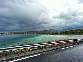
From Olderdalen we took a ferry across Lyngenfjord to Lyngseidet, then drove through the valley to another ferry from Svensby to Breidvik. There's no practical alternative here: there simply aren't bridges and the land route is many times longer. Most local ferries are electric – no rumbling engines, no fumes. The fjord is calm, so we can sit quietly and admire the spectacular landscape of northern Norway.
We reached Tromsø in the evening, exhausted after the day's travelling and actually glad it was raining so we didn't have to go outside.
Total: 293 km


Day 17
Tromsø
Brensholmen
Botnhamn
Fjordgård
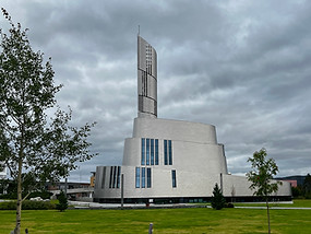
Tromsø is nicknamed the Paris of the North. Its centre is full of historic wooden houses, including the wooden Tromsø Cathedral, the modern Arctic Cathedral and a monument to Roald Amundsen. It commemorates the famous polar explorer who died while attempting to rescue his colleague Umberto Nobile; wreckage from his aircraft washed ashore near the city. Tromsø has all this, along with an incredibly calm, relaxed atmosphere.
In the afternoon we headed for Brensholmen and the ferry across Malangenfjord to Senja. This time it wasn't a super-modern electric ferry but a proper old sea dog from 1972. The crossing was all rolling waves, relentless noise and diesel fumes, tables and stools sliding from one side of the deck to the other – and, of course, wonderful scenery. Of all the Norwegian ferries, this is the one we'll remember: Skutvik.
From Botnhamn we continued to the tiny fishing village of Fjordgård on Ørnfjord. Hemmed in by mountains on all sides, it can only be reached through three very narrow tunnels.
Total: 73 km


Day 18
Segla
We couldn't have chosen worse weather for our first Norwegian hike. But neither wind nor rain stopped us setting off for the ridge between Ørnfjord and Mefjord. What began as a pleasant walk turned into a scramble over slippery rocks and even slipperier moss. The reward was a fabulous view of both fjords and Segla's summit. We didn't dare go any farther: the gale trying to blow us into the fjord showed no sign of easing. So we took up a strategic position behind a boulder, out of the wind, and enjoyed our well-earned Pilsner. As we drank, we watched an older local adventurer, wearing shorts in the appalling weather, slowly climb the rocks all the way to the summit.
We survived the windy night in the car park. In the morning we noticed two hikers huddled inside a car nearby. They told us they'd spent the night just below Segla's summit, unable to sleep, clinging to anything they could to avoid being blown off. Only at dawn, when the wind eased, could they finally descend. Brrr...


Day 19
Day nineteen was meant to be a rest day: just a ninety-minute drive along the fjords to Gryllefjord, then a ferry to Andenes in the Vesterålen islands. We were looking forward to a break from driving.
At Bergsfjord the road climbs over a ridge with sweeping views. We stopped at the Bergsbotn viewpoint to film an educational video in which Petra risked her life explaining the beauty of the landscape. Unfortunately the howling wind and mouthfuls of rain made her completely inaudible, and halfway through her lecture she cowardly fled back to the van.
We reached Gryllefjord, proudly took first place in the ferry lane and discovered the season's last ferry had departed two days earlier. The next one wouldn't run until spring. So we reached Andenes late at night, by road, after seven hours behind the wheel. Not exactly the relaxing day we'd planned...
Total: 430 km



Gryllefjord
Andenes
Day 20
Andenes
Hessand beach
Laupstad
In Andenes, at the far northern end of the Lofoten island region, we sheltered from the windy night behind a sand dune on the beach. The weather improved in the morning and we went exploring. The small town offers more than you'd expect: a polar museum, an extraordinary lighthouse, a major whale-watching centre and even Norway's only space centre. We climbed the 40-metre lighthouse, remarkable not only for being made and assembled from cast iron but especially for its views of the Lofoten islands, Senja and the Norwegian Sea. Petra, who is terrified of heights, particularly enjoyed that.
We gradually made our way south, spent the night beside Laupstadosenfjord and continued the next morning.
Total: 195 km


Day 21
Lofotr Viking Museum
Innersand
You can't visit Norway without going to a Viking museum. We chose the one on the Lofoten islands. The first section displays archaeological finds and artefacts recovered from the sea. The second is a replica Viking longhouse, partly sunk into the ground and furnished with reproductions of everyday objects: sleeping and living areas, storerooms, pantries, workshops and stables. You can touch, sit on and try on almost everything. Naturally we couldn't resist. The flickering fire and dried fish hanging everywhere make it wonderfully authentic. The smell is absolutely horrific.
We planned a hike for the next morning, so we stayed at a farm near the trailhead. Since the North Cape, a little water had occasionally dripped from our ceiling, so we investigated. We bought contact adhesive in town and spent the evening, overlooking a beautiful landscape, dismantling half the ceiling and gluing the loose insulation back into place. We worked for ages and couldn't ventilate much. It turned into a very entertaining evening indeed.
Total: 124 km


Day 22
Kvalvika Beach
Reine
Kvalvika Beach is one of the most beautiful places in Norway, perhaps even in the world. We packed up in the morning and set off. The trail from the farm begins on slippery wooden boards, still preferable to the waterlogged ground beneath them. Then we climb a steep, rocky path into a mountain pass. It starts raining again and, thanks to Norway's habit of hiding trail markers, we repeatedly end up ankle-deep in peat bogs. The scenery changes once more as we haul ourselves higher using safety chains. At last the sea appears in the distance and we descend towards the beach along another wooden walkway. We've seen a lot of beauty in our travels, but nothing quite like this. A magical place that words, photos and videos can hardly capture. So we simply sat and admired it.
In the afternoon we drove south to the famous fishing village of Reine, went out for dinner and fell asleep full of experiences and Norwegian specialities.
Total: 72 km


Day 23
Reinebringen
Å
Moskenes
All evening we'd been gazing up at the mountain we wanted to climb. Reinebringen, towering over Reine, is harder than it looks: 448 metres of ascent in just 1.1 kilometres, like climbing to the 180th floor of a skyscraper. The viewpoint is reached by 1,978 high stone steps built by hired Nepalese Sherpas. This stairway to heaven has no handrails, and in strong winds you could simply be blown off. Fortunately we weren't, and enjoyed our hard-earned views over Reine and the northern Lofoten islands. We passed many exhausted hikers who couldn't continue, whether from fatigue or fear. Understandably.
The southernmost village in this part of the Lofoten islands is Å, a tiny settlement of about a hundred residents whose name means 'little mountain stream'. It has museums devoted to local culture and life. But we arrived late and it started pouring, so we stayed about as long as it takes to pronounce its Norwegian name.
Our day ended at a campsite in nearby Moskenes, where we'd catch the morning ferry to Værøy.
Total: 14 km


Day 24
Værøy
Nordlandshagen
We chose to visit Værøy mainly because stopping here on the Moskenes–Bodø route makes the entire ferry crossing free. After a very rough passage, five motorhomes rolled off the ferry. In an orderly convoy, we all headed to the Ørnhus viewpoint overlooking the island. The more determined continued along the ridge to the Håen radar station. We weren't among them, so we read about the islanders instead. They had raised sheep here for centuries to survive the harsh conditions, but the animals were easy prey for white-tailed sea eagles. So the islanders built small stone bunkers and waited inside with axes for a curious eagle to poke its head in.
With only one suitable overnight spot on the island, all the crews gradually reunited there: the former airport at the island's northern end, closed after the last serious aviation accident in 1990.
Total: 15 km


Day 25
Bodø
Nordnes
Arctic Circle Center
One great thing about ferry crossings is having time to research the next part of the trip. Unfortunately guidebooks don't tell you that public laundrettes seem to be unknown in Norway, and our van was full of dirty clothes. So we had a quick look around town and continued our hunt for a washing machine.
On the way we stopped at another traveller's shrine, the Arctic Circle Center. We'd seen so many photos and videos of it! Inside the door: a souvenir shop, followed by a clothing shop, ending with a shop selling sleeping troll figurines whose full little bellies rise and fall. One stuffed moose, toilets, a cinema. Goodbye. Now we understand why everyone takes their photos outside.
At last we found a campsite with a washing machine. Better still, its restaurant was open. A meal for 120 NOK or all you can eat for 300 NOK. We sat down, loosened our belts and gradually tried EVERYTHING. Not the most polite behaviour, perhaps, but an unbeatable opportunity to discover local food. Reindeer meatballs, something like reindeer stew, roast reindeer with vegetable purée, pork with cabbage, salmon with potato salad. We finished by sampling every dessert, thanked the slightly grumpy owner, rolled back to the van and spent the rest of the day collecting our clean laundry.
Total: 148 km


Mo i rana
Mosjøen
Trofors
Central Norway didn't excite us much. Seven hundred seemingly endless kilometres through a valley with only occasional interesting places to stop. We visited a dairy farm producing some of Norway's most popular cheeses, explored Mo i Rana, the fourth-largest city in northern Norway, and Mosjøen with its 19th-century wooden houses.
We passed the gateway to northern Norway and that evening watched the biggest and longest display of Northern Lights of our entire trip.
Total: 257 km


Stjørdalsfjorden
We arrived at Stjørdalsfjord, an arm of Trondheimfjord. A friend was flying in to join us the next day and we didn't want to spend two days in the city. We found a spot on the shore near a campsite full of permanently parked caravans. Fortunately we were far enough away to have the waterfront to ourselves. Reviews described the owner as friendly and talkative, always keen to know where people came from and where they were going. We certainly weren't bored. We talked all afternoon; he gave us lots of useful tips, explained some Norwegian customs and drank five beers.
Total: 314 km


Hell
Trondheim
The morning drama of delayed flights and frantic connections ended well, and we picked up our friend Ben at Trondheim airport. We'd given him plane tickets and a free bed in our van for his birthday.
Our first stop together was at former submarine bunkers from the Second World War. These enormous concrete structures now serve as warehouses, cultural venues and even gyms. We walked through the city centre along the Nidelva river, lined with beautiful colourful wooden houses, to Nidaros Cathedral. Norway's grandest medieval building is also Scandinavia's largest Gothic church.
We spent the night at a small family-run campsite outside the city.
Total: 45 km


Snøhetta
Dombås
Trollstigen
Åndalsnes
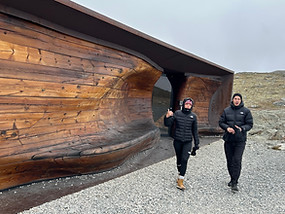
A long day lay ahead, so we had a quick breakfast and set off. Our first stop was a wildlife observation shelter on the edge of Dovrefjell-Sunndalsfjella National Park. Simple yet fascinating, the building combines wood, glass and untreated steel, with views of Mount Snøhetta. An open fire burns inside, and nothing stops visitors from observing Norway's wilderness. Except one small detail: we couldn't see a single animal anywhere. A man with an enormous telescope thought something might have moved on the far side of the valley. To be fair, we were quite glad nothing was running around us. The park is home to musk oxen – half-tonne angry tanks with seemingly no instinct for self-preservation. Imagine a smaller bison, much hairier and much angrier. The campsite owner at Stjørdalsfjord had told us about them. As long as they stay in the mountains, everything is fine. But sometimes one wanders down into the valley and, for example, charges headfirst at a moving train. Just a normal Norwegian animal.
Via Dombås, a crossroads for Oslo to the south, coastal Åndalsnes to the west and Trondheim to the north, we reached Isterdalen. At the valley's end begins the famous Trollstigen, the Troll's Ladder. Eleven hairpin bends wind up the mountainside from sea level to 800 metres. A bridge crosses Stigfossen waterfall, where water from Lake Alnesvatnet tumbles into the valley. Fog spoiled the view from the very top, but it was still unforgettable. And because we arrived after the season, late in the day, we had the entire road to ourselves.
We drove down to Åndalsnes on Romsdalsfjord for the night.
Total: 328 km


Rampestreken
Ålesund
High above Åndalsnes lies the Rampestreken viewpoint, overlooking the whole town, much of the fjord and the surrounding mountains. We didn't fancy walking, so we opted for the cable car. First into the car park, tickets already bought online, we waited impatiently at the entrance. And waited... and waited. By the time about twenty people were waiting with us, a member of staff came out to explain that the cable car wouldn't open until noon. Not great news at 9 a.m. when we needed to catch Ben's flight from Ålesund. Still, we had tickets, we should make the flight, and we still didn't fancy walking. So we passed the time at a café run by young Czechs and wandering around town.
We reached Ålesund in time, dropped Ben at the airport and drove into the centre. We found one of the best urban camping spots of our trip: right on the water, in a peaceful part of town but close to the centre. As a bonus, we could watch Ben's plane taking off across the fjord.
Ålesund is a small, charming city spread across three islands. After it burned down completely in 1904, it was rebuilt in the fashionable architectural style of the day. That's why it remains a unique showcase of Art Nouveau architecture.
We ended our evening walk on Mount Aksla, with fantastic views over the city and harbour, where one of those enormous cruise ships was moored.
Total: 108 km


Geiranger
Dalsnibba
Lake Lovatnet
Another of Norway's natural wonders awaited us today. The two-and-a-half-hour drive through mountains and fjords flew by; there was always something to look at. Ferry crossings had become routine and the kilometres slipped away.
We stopped at a viewpoint above Geirangerfjord, which many travellers call the most beautiful fjord on Earth. We can see why. This 15-kilometre glacial fjord has been a UNESCO World Heritage Site since 2005. There was just one blemish: an enormous cruise ship anchored at the end, sending countless tourist boats ashore. And yes, it was the same ship we'd seen yesterday in Ålesund.
We wound down a series of hairpin bends to the water and continued through the valley into the mountains. We passed the crowded centre of Geiranger, made up almost entirely of hotels and a campsite, dodging tourists and the tiny rental electric cars in which young visitors were racing around. We couldn't wait to get back to the mountains.
Climbing steeply again, we entered a completely different world within a few kilometres. The endless green forests were gone, replaced by rocks and lichen. Southeast of Geiranger we passed the toll entrance to Mount Dalsnibba. An older French traveller coming down in her old van made our decision about paying for us: 'Go! It's worth it! And best of all, their payment system is broken, so it's free!' Up we climbed to almost 1,500 metres. The drive itself was breathtaking, with a new view around every bend, even of Jostedalsbreen, Europe's largest mainland glacier. And the view from the summit? Priceless.
Total: 212 km


Borgund Stavkyrkje
Tyssedal
After a night beside the turquoise waters of Lake Lovatnet, we headed into the Lærdal valley to see Norway's best-preserved stave church. Decorated with mythical animals, dragon heads and runic inscriptions, the church is dimly lit, its small windows looking out onto the medieval cemetery surrounding it. Built in 1180, this majestic wooden structure looks as though it belongs in a dark Nordic fairy tale, perfectly matching the misty valley.
We left the valley through the Lærdal Tunnel. At 24.5 kilometres long, it is divided into three sections separated by widened, colourfully illuminated chambers, helping drivers stay alert and providing a striking sight.
The final stretch to Tyssedal was tough. We'd driven 400 kilometres that day, darkness had fallen, and the narrow road beside Sørfjorden, barely wide enough for two cars to pass, was partly under construction. Roads are being built and repaired throughout Norway, sometimes simply to straighten a winding valley road and save a few minutes. One particularly amusing Norwegian custom is to stop at a red light at the roadworks and wait. After several minutes – sometimes tens of minutes – a marked roadworks vehicle arrives to lead you through. It always carries the prominent word LEDEBIL.
And why Tyssedal? This unremarkable village is the starting point for one of Norway's greatest sights: Trolltunga, the Troll's Tongue. Time for bed. Tomorrow means a very early start and a 22-kilometre hike through beautiful but unforgiving wilderness.
Total: 402 km


Trolltunga
Langfossen Waterfall
Tysværvåg
Die Nacht in einer dunklen Ecke des Parkplatzes verging wie im Flug und wir wachten noch vor Sonnenaufgang auf. Wir wollten den ersten Bus erwischen, der Wanderer vom Parkplatz P1 nach P2 bringt. Wegen der Größe unseres Vans durften wir selbst nicht weiterfahren. Wir zogen uns ordentlich warm an, packten Wechselkleidung, Essen und Getränke in die Rucksäcke und warteten an der Haltestelle. Dort stand ein kleines Auto, aus dem ein freundlicher älterer Herr in einer orangefarbenen Weste stieg und uns aufmerksam musterte. „Habt ihr vernünftige Kleidung? Wasserdicht? Warm genug? Essen, Trinken? Kennt ihr die wichtigsten Informationen?“ Der Mann war einer der Gründer des Vereins, der Trolltunga weltweit bekannt gemacht hatte. Er erzählte uns, dass vor 2018 fast nur die Einheimischen die Trollzunge kannten. Nachdem der Verein eine riesige Werbefläche am Times Square in New York gebucht hatte, stieg die jährliche Besucherzahl von 800 auf 80.000 Menschen. Das brachte vor allem Probleme für die Natur mit sich, aber auch für die Besucher, die ihre eigenen Kräfte und die Gefahren der nordischen Landschaft unterschätzten. Er selbst hatte mehrere Menschen vor dem sicheren Tod gerettet. Deshalb begannen sie mit Aufklärungsarbeit. Am Anfang des Weges stehen zahlreiche Warnschilder mit Zeitangaben, Ausrüstungsempfehlungen und Karten, auf denen Notübernachtungsplätze und mögliche Hubschrauberlandeplätze eingezeichnet sind. Und die Hubschrauber werden jedes Jahr mehrfach gebraucht. Entlang der Strecke gibt es Markierungen, an schwierigen Stellen Kettengeländer und außerdem zwei Notunterkünfte mit einer Grundausstattung zum Überleben.
Der Bus kam und wir verabschiedeten uns. In Skjeggedal stiegen wir aus und hofften, zu den bereits eingesparten fünf Kilometern Fußweg noch weitere dreieinhalb hinzufügen zu können. Dabei ging es uns weniger um die Entfernung als um 430 Höhenmeter und anderthalb Stunden Zeitersparnis. Wir hatten Glück: Nach zehn Minuten kurvenreicher Fahrt mit einem Kleinbus stiegen wir zusammen mit einigen anderen Wanderern in Mågelitopp aus – dem Ausgangspunkt unseres Treks.
Der Weg begann ganz gemütlich. Die ersten anderthalb Kilometer führten mehr oder weniger über ebenes Gelände. Dann folgte jedoch ein mörderischer, anderthalb Kilometer langer steiler Aufstieg zu einem Pass zwischen den Gipfeln. Nach und nach legten wir Kleidungsschichten ab, nur um sie kurz darauf wieder anzuziehen. Es begann heftig zu regnen und zu stürmen. Schließlich erreichten wir Trombeskar. Drei Kilometer hatten wir geschafft. Und sollte noch irgendwo ein trockenes Stück Kleidung übrig gewesen sein, hätte die aufsteigende Feuchtigkeit es ohnehin vollständig durchnässt.
Der mittlere Teil der Route führte leicht bergauf am Rand einer 700 Meter hohen Felswand über dem See Ringedalsvatnet entlang. Vor dem unerbittlichen Wetter suchten wir kurz Schutz in einer der Notunterkünfte, aßen unsere Brotzeit und machten uns auf den letzten Abschnitt. Wieder ging es über nasse Felsen auf und ab, vorbei an unzähligen Bächen und kleinen Seen. Jetzt begegneten wir auch den ersten Wanderern auf dem Rückweg, die noch früher aufgebrochen waren als wir. Alle Gruppen wurden von einheimischen Führern begleitet. Vermutlich waren sie noch im Dunkeln losgegangen, um den Ort für sich allein zu haben.
Etwa eine Stunde vor dem Ziel sahen wir in der Ferne auf einer Wiese eine Neuheit für Touristen: ein großes gläsernes Iglu, in dem man übernachten kann. Für schlappe 4.750 NOK, also rund 10.000 tschechische Kronen, pro Person kann man Trolltunga am Abend und am Morgen erleben und an einem wirklich einmaligen Ort essen, schlafen und frühstücken.
Wir hatten auf dem Parkplatz geschlafen und gefrühstückt. Nach drei Stunden und elf anstrengenden Kilometern erreichten wir endlich unser Ziel. Und wir hatten Glück. Nur wenige Menschen waren da, sodass wir nicht stundenlang anstehen mussten. Wir sahen uns in Ruhe um, machten Fotos, ließen uns Zeit und genossen vor allem diesen einzigartigen Ort. Das Gefühl, etwas Großartiges geschafft und den inneren Schweinehund besiegt zu haben, wurde nur durch eine Sache getrübt: Eigentlich hatten wir erst die Hälfte der Wanderung hinter uns. Den ganzen Weg mussten wir auch wieder zurück.
Und ja, auch wir begegneten unterwegs einigen Abenteurern in Jeans und weißen Turnschuhen, völlig erschöpften Touristen und Instagram-Verrückten, die für ein Foto in den sozialen Medien ihr Leben riskieren.
Noch am selben Abend fuhren wir mit unserem Van weiter Richtung Süden. Unterwegs hielten wir am Langfossen, einem Wasserfall, der aus 612 Metern Höhe herabstürzt. Und weil es seit ungefähr einer Woche ununterbrochen geregnet hatte, führte er wirklich jede Menge Wasser.
Insgesamt 144 km


Sverd i fjell
Stavanger
Jørpeland
After the previous day's exertions, we prescribed ourselves a rest day: less than 100 kilometres, including a drive through Stavanger, Norway's fourth-largest city. We stopped at Sverd i fjell (Swords in Rock), a monument to the battle of 872, when King Harald Fairhair defeated two rivals and united Norwegian territory. Alongside tourists from a cruise ship (yes, still the same one), we admired the monument, walked around Stavanger and continued to Jørpeland.
In Jørpeland we parked at the marina, with wonderful views of Lysefjord and our favourite supermarket, REMA 1000. We washed our dirty clothes and gathered strength for the next day: a hike to Preikestolen, the Pulpit Rock, towering 604 metres above Lysefjord.
Total: 94 km


Preikestolen
Sandnes
Today's the day: our final Norwegian hike. In the morning we drove less than ten kilometres to the trailhead car park for Preikestolen. The sheer number of cars and hikers of every age, from small children to pensioners, suggested the route wouldn't be too difficult – or quiet. The path climbs steeply from the car park and within minutes we had our first views. The landscape wasn't especially dramatic at first: gently rolling wooded hills, rather like those back in the Czech Republic. But that soon changed. We reached a rock face with our beloved Himalayan-style stone steps, and up we climbed again, knees creaking. The total ascent is 460 metres, much of it on various steps. After 2.5 kilometres, when you reach Lake Tjødnane, Lysefjord appears in the distance and, most importantly, the rest of the trail is fairly easy.
Preikestolen is an extraordinary place, well worth the hike. Panoramic views stretch over the surrounding landscape and the fjord far below. If you're as lucky as we were, only a few other tourists will be there and you won't have to queue an hour for a photograph.
And a few final observations. Right on Preikestolen we saw an older woman come within a fraction of a second of falling into the fjord. At least she'd have had a nice final Instagram photo. On the way up we counted hikers coming the other way, but somewhere around kilometre three we gave up at 500. And this was outside the season. Yes, some came from our favourite cruise ship, always carefully labelled. We can't understand parents hauling pushchairs along this route, and we curse everyone who drops litter. We collected two plastic bags of tissues, sweet wrappers, bottles and even a shoe. At least the owner of that last item had punished themselves. To restore a little faith in humanity, the parking attendant saw what we were doing and gave us free parking for the day. During the high season, he told us, he climbs to the Pulpit Rock twice daily and returns with at least two full rubbish sacks each time.
Total: 62 km


Oslo
Øyenkilen
Our final stop in Norway was Oslo. Ever since the North Cape we'd noticed our confidence in leaving the van parked anywhere without worry gradually fading. Oslo was the icing on that particular Norwegian cake. We parked in a small central car park full of other motorhomes and set off to explore. The city certainly deserves more time, but after six weeks surrounded by nature, this was almost too much civilisation for us. At least we visited the Opera House, whose roof forms a viewing terrace sloping towards Oslofjord, and the Edvard Munch Museum, which displays one version of his most famous painting, The Scream.
Total: 633 km


Göteborg
Sweden is a beautiful country, but in recent years it has been struggling with a sad reality. While planning our stop in Gothenburg, we found travel reviews warning against sleeping anywhere except a very expensive campsite. Almost everyone described vehicle break-ins, gangs apparently selecting victims, or even shootings. So we arrived at a campsite unlike any we'd seen before: barbed-wire fencing, security guards at the entrance and signs everywhere warning against parking outside. We left the van under the watch of countless security cameras and headed into town.
Gothenburg is beautiful, but our sense of calm was spoiled by groups of young immigrants hanging around, whom we perceived as waiting for an opportunity. Meanwhile Swedish locals hurried home from work to their families. It felt to us like two worlds that couldn't coexist. As darkness fell, we retreated to a restaurant for dinner and then took a taxi back to the campsite.
The next day we wanted to understand more about what we'd seen. We found an interview with a Swedish police officer responsible for Gothenburg's immigrant neighbourhoods. That subject doesn't really belong in a travel diary, so I'll only add that two murders were reported in the city on the evening we walked through it.
Total: 225 km


Copenhagen
Rødby
Puttgarden
After our experience in Gothenburg, we weren't keen on another Swedish city, so we drove straight through Malmö. But there was one thing we couldn't miss: the famous Øresund crossing linking Sweden and Denmark. The entire connection between Scandinavia and western Europe is 16 kilometres long. First comes a bridge just under eight kilometres long, then a four-kilometre artificial island, followed by a 3.5-kilometre underwater tunnel. Another 430 metres across an artificial peninsula and you're in Denmark.
Like proper tourists, we admired Copenhagen from the van. Our only stop was a grocery shop in the centre, after which we slowly crawled out of the city through lunchtime traffic. From Rødby in southern Denmark we took the ferry to Puttgarden in Germany, spent the night and headed home.
And the loveliest moment of the entire journey? When Madla received a piece of driftwood we'd brought her from a Norwegian fjord ❤️
Total: 1,265 km


